Entire unit of work on Antarctica

If you can't remember where names like Mawson, Shackleton and Scott fit into the history of the early twentieth century then you are sorely missing the key players in the gripping history of Antarctica. 

Ernest Shackleton's feats in my humble opinion are as amazing as any human feat in history.  This guy was a living breathing super hero. 

Not to mention the fact that Antarctica is one of the most beautiful and unique places on earth.

Here is a great unit of work for those of you wanting to teach and learn about Antarctica.  It is pitched at year 5/6 students but there is plenty in it for all ages.

Download the PDF here.

Antarctic Documentary from IMAX below

Lesson Plan: Surveying Data and Creating a Graph

This is a single lesson aimed at upper primary aged students (aged 9 -12 ) about collecting data, creating graphs and analysing the data you have collected.  All of the resoruces are contained within the planner.

Download the entire PowerPoint Presentation here. (recommnded)

Download a PDF of the lesson plan here.

View more presentations from Kevin Cummins.

•This lesson will assist students in further developing their knowledge of fractions, decimals and percentage.

•The data collected can also be used in developing an understanding of graphical representation in the form of graphs; for example: Pie, linear, bar graphs etc.

Useful tutorial on how to do long division for teachers and students

I have to teach long division tomorrow for the first ime in a long time and all i remember about it is that it is a long, confusing and involved process.  Instead of fumbling through text books to refresh my memory I was straight on to the web and found this brilliant step by step tutorial (below) that I will work through with my students.  It is really comprehensive and easy to follow.  I hope you enjoy it and get some use out of it.


Teach your students about the mathematical concept of estimation

Estimate is a great interactive site that allows students to estimate a number that an arrow is pointing to on a number line. This is great for students who are first learning about estimation. It is an easy to use site that is fairly robust and would be useful to students of all ages.  Access it here.

Google Public Data Explorer - A Ton of Math's Possibilities

Just found this today and I would definitely recommend taking a look at it with your students especially if you are looking at chance and data.

Google Public Data Explorer, a part of Google Labs experiments, is a tool that helps you explore through and visualize public datasets that are made available by government and other agencies that track stats, from around the world.

public data explorer 1

There are a number of datasets available. You can check out the government debt in Europe or visualize the unemployment rate in the United States, see how the US population is growing or the variations in prices of natural gases around the world.

It offers four kinds of visualizations for most of the datasets: line chart, bar chart, map or bubble chart. You can easily switch from one chart format to the other.

public data explorer 2

You could also compare the data for specific countries for datasets that aggregate data from an entire continent. For example, in the graph, I’ve compared the broadband penetration rate in specific countries in Europe.

public data explorer 3

The charts and maps can also be embedded in your website or blog. Overall, a nice tool for students and scholars and could definitely aid in their research on a topic.

The ultimate guide to Google Earth for Teachers and Students

When Google Earth launched in 2004 it was one of the web’s original ‘Wow!’ tools that people really stood up and took notice of.  Today it is in an industry standard in local government for zoning, transport and a multitude of other uses and industries.  As Google’s new high definition satellite gradually covers more of the planet we will also see it in greater detail which will again open up new opportunities for the creative and entrepreneurial minded individual. 

Street View, Space, Measuring Tools, Ocean Floors, 3D scapes, Photos and even historical overlays are just some of the additions to Google Earth that continue to grow this great classroom  resource.  Today I have compiled my top Google Earth Resources and Sites for Teachers for you get the most out of it for you and your students.  I hope you enjoy it.

Stop by at Google First:

If you are an absolute beginner with G.E in the classroom then this is your first stop.  You will find a great getting started section with video tutorials, lesson ideas and give you 10 simple tasks to do with your students that will get the ball rolling.  Click here to access the Google Earth for Educators home page.

Google Earth Pro for Free.

Did you know Google Earth Pro is Free for Educators?  Google Earth Pro allows you to access higher resolution images, it is ad free, allows you add overlays for others, create movies as well as much more.  I would start here if you really want to become serious about using Google Earth as it does allow for far greater opportunities.  Click here to find out how to access it for free.  It will only last for a year at this stage but will save you $400 straight up. 

Google Earth 101

This is an excellent Wiki that will require registration but once you are in it offers in depth tutorials on areas such as:  Shortcuts, How to examine environments, creating screen casts and understanding layers, curriculum ideas and further G.E Links  Nearly all of these are video tutorials which means both you and your students can learn together.  Click here to access Google Earth 101 a great Resource by Quentin Desouza.

Google Earth Lessons

Much like its name suggests Google Earth Lessons is a hub of “How To’s” Student controlled Lessons, Teacher controlled and mini lessons on a range of searchable curriculum areas such as maths, literacy, science and so on.  A great site by a dedicated teacher that you must visit.  Check it out here.

Google Earth Resources and Tools for Educators

Here you will find multitudes of applications to use alongside G.E, dedicated, G.E Blogs, Lesson Ideas and basically all things Google Earth and education.  A must see for those looking further.  Click here to access it.

Google Earth for Geography Teachers

Last but not least G.E is probably the greatest geography tool since the atlas was created hundreds of years ago.  So if you are a geography teacher who really wants to dig their teeth into physical and political boundaries of the world then this is the site for you.

Teach your students how earthquakes happen

What is it? Following last weeks disastrous events in Haiti, Earthquakes may have been a topic of discussion in your classroom either in terms of humanitarian relief or actually enquiring about the physical causes and effects of Earthquakes.

The BBC has a brilliant brief animated sideshow that explains the causes and effects of Earthquakes which makes a very complex issue seem very simple.  It is also available in a printable PDF format if you so desire to use as handouts.

How can I use this in my classroom? Here is a great link to a BBC News Article on the Haiti Earthquakes explaining the turn of events along with a video clip.  (please note that the clip may not be appropriate for all students due to it's graphic nature - use at your own discretion.) Ask you students what they know about Earthquakes and why they occur?

Brainstorm class ideas on the board and then share the BBC Earthquake Explanation animation.

Discuss how some countries on fault lines will always be subject to Earthquakes in the future and how they can also cause Tsunami's and spread danger far wider than just the centre of the quake.  Ask students what can be done in these areas to minimise the effects of Earthquakes?

Students can then record their knowledge of Earthquakes either in whatever format you desire.  Write a survival story based on their knowledge learnt or research some famous Earthquakes from the Past.

Finally it would be great if you could brainstorm a class or school fundraiser that could help the victims of the Earthquake in Haiti.

Look forward to hearning of any great lesson ideas you have realted to the Earthquakes.

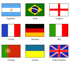
All you need to know about the flags of the world

FLAGITUP provides national flags from all the major countries in the world and lots of information on each particular country. Users can learn about the countries of the world and even take up the challenge of the Flagitup quiz!